Your cart is currently empty!
[ad_zone zone=’7′]
Posted in
On January 30, six of the seven Colorado River basin states jointly released a proposal to the Bureau of Reclamation (USBR) in response to that agency’s January 31 deadline to avoid facing possible preemptive federal intervention. Technically, it’s a request for the USBR to analyze this proposal in their upcoming Supplemental EIR to address changes to the 2007 Interim Guidelines, the outcome of which will guide future operations related to the river starting in 2026.
Notably, California did not sign on to the proposal. That state intends to submit its own plan for consideration by March. It’s likely that as the state with the most to lose in potential cutbacks from water use (especially agricultural water use in the Imperial Valley), California considered that the proposed plan was too unfavorable to its interests.
For simplicity, I’ll call the new proposal the “Six State Plan”. It’s not that long—only 9 pages—but it is complicated, because it considers multiple inputs related to cutting back water use. Procedurally, the plan focus on modifying aspects of the existing 2007 Interim Guidelines in order to implement its provisions.
So what does it actually say? Without getting too deep into the details, here are its basic provisions:
The guiding principle of the plan is to ensure that both Lake Mead and Lake Powell retain enough water to provide power, and in the case of Lake Powell, to ensure that necessary water deliveries to the Lower Basin are still possible.
To achieve this, it calls for specific cutbacks in existing water use in the three Lower Basin states and Mexico, but not in the Upper Basin states. The rationale for that is that the USBR cannot control diversions prior to the rivers reaching various reservoirs, such as Lake Powell. The plan does leave open the possibility—and encourages—cutbacks from the Upper Basin if Lake Powell drops below 3550 feet above sea level, to avoid getting too close to the minimum power pool elevation of 3490.
Lower Basin cutbacks would be based solely on the level of Lake Mead, not Lake Powell. The plan establishes nine tiers of progressively greater cutbacks when the surface elevation of Lake Mead drops from 1090 to 1000.
Cutbacks and resulting water use would be based on the average water use for each state from 2019 through 2021.
For the first time, water use accounting in the Lower Basin would account for system losses—mostly evaporation—which until now have not been considered in their reported use. The collective loss reported in the plan would be 1.543 million acre feet (maf), which would count against water use in the Lower Basin states and Mexico, similar to how water accounting is currently done now in the Upper Basin.
Cutbacks for each state and Mexico would not be applied evenly, or by percentage. The calculation includes several complex factors, but in the end, the magnitude of total cutbacks would range from about 1.8 to 3.4 maf when Lake Mead is below 1090. That’s a 20-40% cut from the existing use in the Lower Basin. The largest cuts occur when Lake Mead is below 1020. It is currently at 1047.
The magnitude of possible cutbacks would vary by state and Mexico, with Arizona taking the largest share by percentage from its baseline use (for a variety of reasons explained in the plan):
AZ – 24-50% (0.60-1.25 maf)
NV – 10-27% (0.03-0.07 maf)
CA – 18-35% (0.77-1.42 maf)
MX – 26-42% (0.39-0.62 maf)
The proposal calls for increasing the Lake Powell elevation at which releases from through Glen Canyon Dam would be reduced from 7.48 to 7.0 maf. Under the 2007 Interim Guidelines, that elevation is 3525; in this proposal, it would be raised to 3550. This move would have the effect of propping up Lake Powell when it is low, and reducing the need for the Upper Basin states to be forced to make additional water use cuts to protect Lake Powell.
The proposal establishes that releases could be increased as needed in order to prevent Lake Powell from dropping below 3500.
That’s it in broad strokes. The plan asks a lot from the Lower Basin, and nothing concrete from the Upper Basin. And yet, both Arizona and Nevada are on board with the concept.
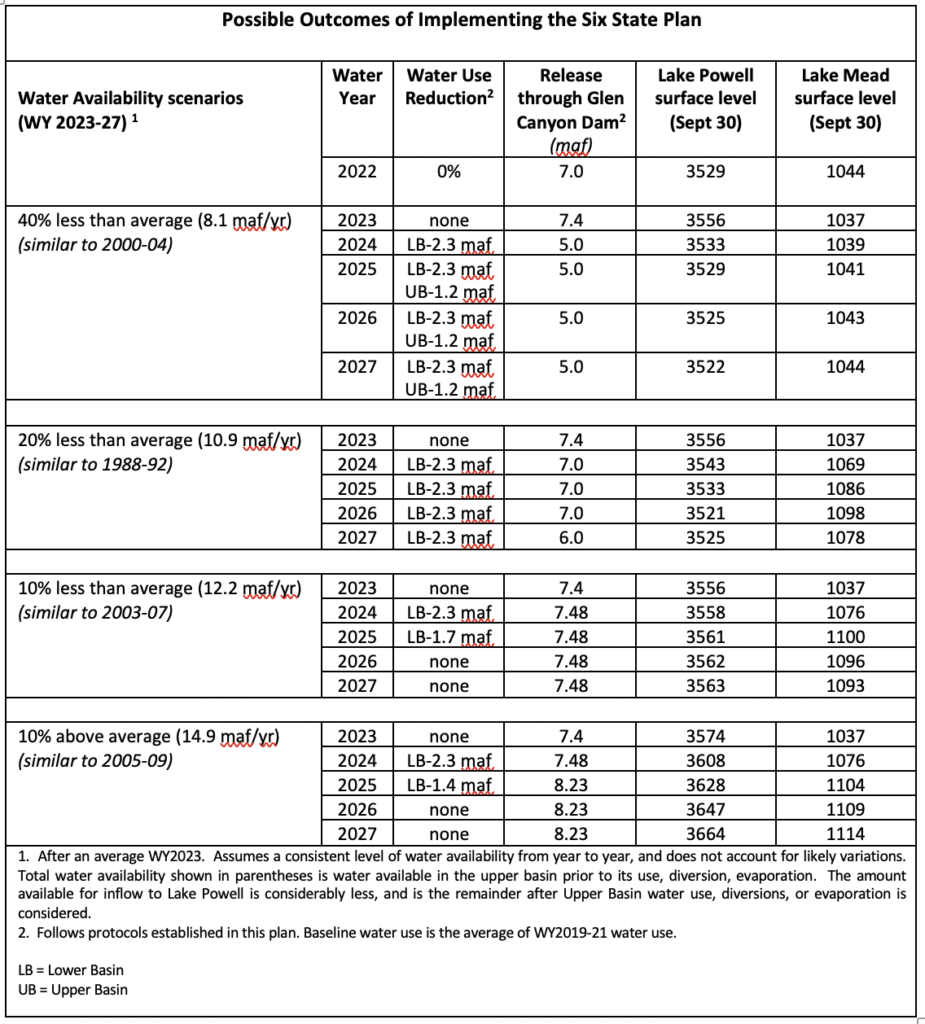
But would the Six State Plan work? Would it protect the reservoirs? After analyzing various scenarios, including one in which the 4-year period 2024-27 is consistently 40% below average runoff, the answer appears to be Yes. This modeling also assumed there would be no water use cutbacks in 2023, and that we’d have at least an average runoff year, which seems like a safe bet at this point.
The table spells it out. Under every scenario, both Mead and Powell would stay well above minimum power pool (950 and 3490, respectively) through 2027. Only in the more extreme scenarios (at least 20% below average water years) would the Upper Basin have to make additional cutbacks in its use to keep Lake Powell viable. And in even in slightly above average years, Lake Powell makes a strong recovery, well above 3600 by 2025 if the average snowpack is at least 10% above average in aggregate.
It seems like a solid plan, and the modeled results look encouraging. It’s debatable whether or not it’s fair to the Lower Basin, which is probably why California is absent. But it’s a workable plan. In my view, I think the Upper Basin should share more responsibility, although I understand the rationale—they have historically used much less river water than the Lower Basin, and they feel entitled to an equal share under the 1922 Compact. But the clear need—where most of the people live, and where most of the irrigated crops are grown—is in the Lower Basin.
Let’s see how this plays out…
Tags:
You may also like…

[ad_zone zone=’8′]
Visit the AZBackroads.com Store

Please Become A Member
We need your help to keep our backroads open. Please join today!


