There is another law working its way through the capital. HB2456 is an appropriation sought by Republican Representative Leo Biasiucci. The new law establishes a one-time budget for four million dollars in funding. The monies are to be split between counties to install an interoperability communication system.
The new law reads as follows:
Be it enacted by the Legislature of the State of Arizona:
Section 1. Appropriation; state treasurer; rural county interoperability communication system
The sum of $4,000,000 is appropriated from the state general fund in fiscal year 2022-2023 to the state treasurer for a rural county interoperability communication system that:
1. Enables the deployment of secure, multimedia data communications system to a user base consisting of public safety agencies.
2. Provides a communications solution environment that allows for identifying a system user’s identity, location and operational status during an incident, secure text messaging and file sharing to all users involved in an incident, secure sharing of collaborative maps, building floor plans and images, integrating manually activated panic alarm systems that, when activated, establish direct collaboration between public safety agencies by using multiple forms of real-time communications and information collaboration, including voice and full-motion video sharing, during an incident.
3. Is capable of being deployed to end users on existing communication assets owned by participating entities.
4. Allows each participating entity to maintain discretionary real-time control of all communications assets owned or operated by the entity.
5. Encrypts all media communications.
6. Ensures staff privacy.
7. Is United States department of homeland security safety act certified qualified antiterrorism technology.
8. Is compatible with federal emergency management agency interoperable gateway systems for disaster communications.
Dipping into the OHV Fund to subsidize the cost
During a vote in the House Land, Agriculture, and Rural Affairs Committee, Republican Representative David Cook from Legislative District 8 took a minute to explain his vote. He asserted his concern over the high cost to rural schools. He ended his statement by implying the acquisition of funding from the state OHV Fund to subsidize the cost.
Watch below.
HB2456 has made its way through the House Commities.
This is being disguised as a tool for law enforcement and border security. By watching the debates, it appears House Republicans have no idea what this technology is.
Please contact the legislature and tell them to vote NO on HB2456.
Statewide Interoperability
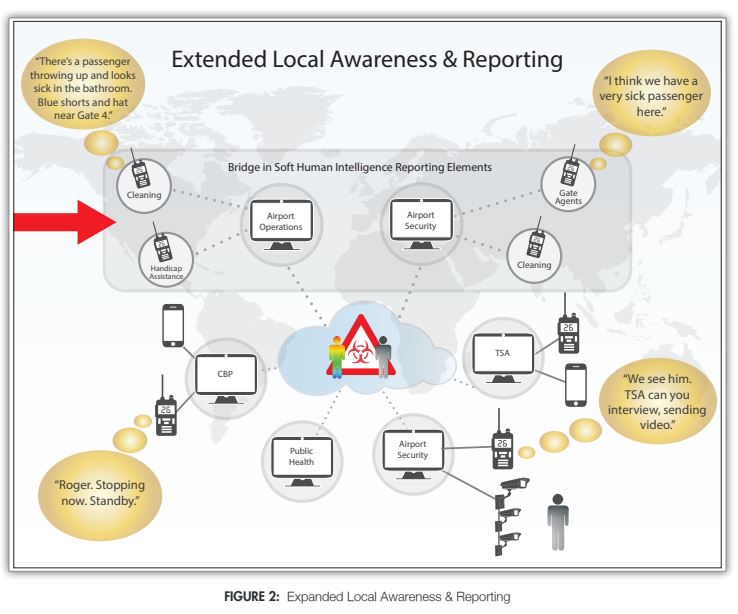
The funding is being sought after by a Connecticut-based company called Mutualink. Mutualink specializes in Interoperability that allows government agencies, security firms, and private entities deemed significant to public affairs to share text, voice, video, location, and other data in real-time to improve cross-agency communication. They are certified by the Department of Homeland Security Safety Act and manage the Interoperable Gateway System, part of the federal government’s National Continuity Program.
During testimony before several standing committees, a Mutualink representative alleges that the interoperability system will be used to help reduce response times to incidents involving law enforcement. They claim that the system could integrate with existing legacy systems like surveillance cameras, radio communications, and other systems used by local government and connect them under a single network to share real-time data.
The Mutualink representatives used various examples explaining that the money would be used to expand an existing system to the needs of local Sheriffs. Last year, the current system was put in place and is currently installed in schools in 5 Arizona counties. They say the system can notify a network of first responders and other government entities during a critical incident. Some examples are given described a scenario where school bus drivers are advised of flooded water crossings on rural roads; the use of a mobile application with a panic button and capabilities of sharing real-time video and audio data during an emergency;
Meat New Hampshire’s contact tracer
On their website, Mutualink boasts about helping New Hampshire become the first state to assemble a statewide interoperability system and deploy it in response to COVID. On June 24, 2020, New Hampshire released a COVID-19 Case Investigation and Contact Tracing Plan revealing the robust capabilities of their new system. On pages 45-46, they describe their Electronic Disease Surveillance System and highlight interoperable data sharing as a critical feature of the program.
Contracts under public records show that New Hampshire purchased everything from gateways to integrate existing systems to motion sensors, shock sensors, and thermal imaging cameras from Mutialink. Later in the article, they make the following statement on page 48.
“The Epidemiology and Surveillance Unit works alongside the Case Investigation, Contact Tracing, and Cluster Investigation Units to analyze, interpret, and disseminate response data.”
In a published white paper titled Ensuring Preparedness during Healthcare, Crises Mutualink brags about utilizing contact tracing to combat the 2015 Ebola outbreak in West Africa. They stress how Interoperability and data collection from citizens helped fight the spread of Ebola.
In an article on their website titled Interoperable Communications Essential for COVID-19 Response, Mutualink says the following.
“Also, connecting the health care system to enable real-time coordination with emergency managers and public safety agencies performing an array of support functions is equally important. These include identifying suspected sick persons in the field, rendering first aid, assisting with personnel transport, ensuring security at testing and health care delivery sites, and, if needed, enforcing quarantines and ensuring distribution of essential items to those in need.”
Mutualink also has this page on their website identified as Human Infection with 2019 Novel Coronavirus Person Under Investigation (PUI) and Case Report Form that allows medical professionals to report coronavirus patients as a PUI (Person Under Investigation) to the Center for Disease Control. This page collects multiple pieces of data about a person’s current health condition. It asks for various identifying numbers and personal information, including name, birth date, testing status, symptoms, pre-existing conditions, and other invasive details.
What is Interoperability?
The U.S. Army defines Interoperability as follows.
“The ability to routinely act together coherently, effectively and efficiently to achieve tactical, operational and strategic objectives. Interoperability activities are defined as any initiative, forum, agreement, or operation that improves the Army’s ability to operate effectively and efficiently as a component of the joint force and as a member or leader of an alliance or coalition across the range of military operations.”
Army Regulation 34-1, Multinational Force Interoperability
Interoperability is not contact tracing. Instead, it’s a key component of contact tracing that brings the system together under a central network where all things connect through gateways. Through gateways, existing systems integrate the information concentrated in a single piece of computer software.
Among other specialties, the software uses blockchain technology to collect and share real-time public and private data to connect various government agencies during an incident. As mentioned on Mutualink’s website, these systems are also used to create Smart Cities and allow multiple devices to exchange data in real-time. The systems are compatible with voice, text, video, and data communication between government entities, cities, and statewide networks. These systems also integrate with Artificial Intelligence, robotic/automated systems, and the Internet of Things.
The United Nations Data for the Sustainable Development Goals website describes Interoperability as “A global network using data to achieve the Sustainable Development Goals – improving lives, fighting inequality, and promoting environmental sustainability.” The U.N. has set the standard for interoperability data collection and provides guidance to practitioners through their Data Interoperability Guide, and E-Government Interoperability Guide set forth by the United Nations Development Program in partnership with IBM and Oracle.
The Global Partners for Sustainable Development Data published a U.S. SDG Data Revolution Roadmap report. This document was produced by the United States under the 2030 Sustainable Development Agenda and noted the following:
“THE 2030 SUSTAINABLE Development Agenda called on all United Nations
member countries to report data against the 17 Sustainable Development
Goals and their associated 169 targets. In May 2016, the U.S. Government
took stock of the government’s ability to report official statistics for each of
the initial indicators. The effort was led by the Office of the Chief Statistician
in the Office of Management and Budget (OMB), which convened an Expert Group on SDG Indicators. The group determined that the U.S. has data sources for half of the SDG indicators, could develop proxy indicators for a small number, and needs to find new data sources for the rest.In tandem with this exercise, OMB developed a National Reporting Platform (NRP) for SDG indicators. A beta version of the platform was developed with input from the Department of State, the General Services Administration, and the White House Office of Science and Technology Policy. OMB began using this National Reporting Platform to publish statistics on SDG indicators in September 2016.
The platform will help determine how well the U.S. is working to achieve the SDGs, and can serve as an open source model to enable other countries to develop their own platforms and their statistical capacity. The National Reporting Platform is designed to promote data interoperability to support international reporting requirements. It launched as part of Data.gov, the U.S. Government’s open data portal, which provides public access to nearly 200,000 datasets.
The current National Reporting Platform is an initial platform, at an early stage of development, that can begin to show how well different parts of the government are working toward the SDGs. The OMB is simultaneously running two versions of the NRP, one for the public (http://sdg.data.gov) and one for the technical community to preview indicator data (https://gsa.github.io/sdg-indicators). OMB and its collaborating agencies are actively seeking feedback on the NRP from both general and technical users.”