

Palo Verde Regional Park Recreation & Public Purposes Act Lease
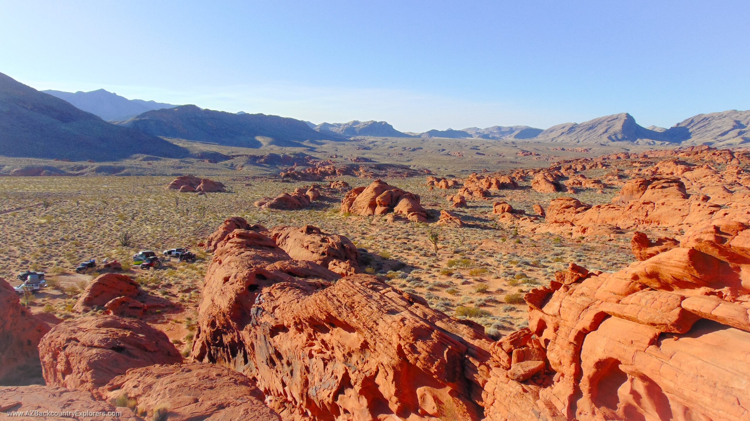
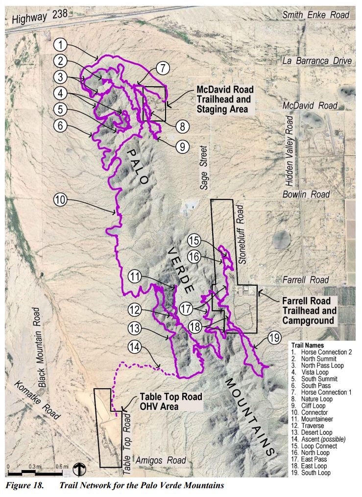
Pinal County has applied for a lease under the Recreation & Public Purposes Act to create a county park that will include several amenities catering to local outdoor enthusiasts. The project area is located on 393 acres of public land in the Palo Verde Mountains just west of Maricopa, Arizona, in a popular OHV area managed by the Bureau of Land Management. The proposed park consists of three regions and does not encompass the mountain range.
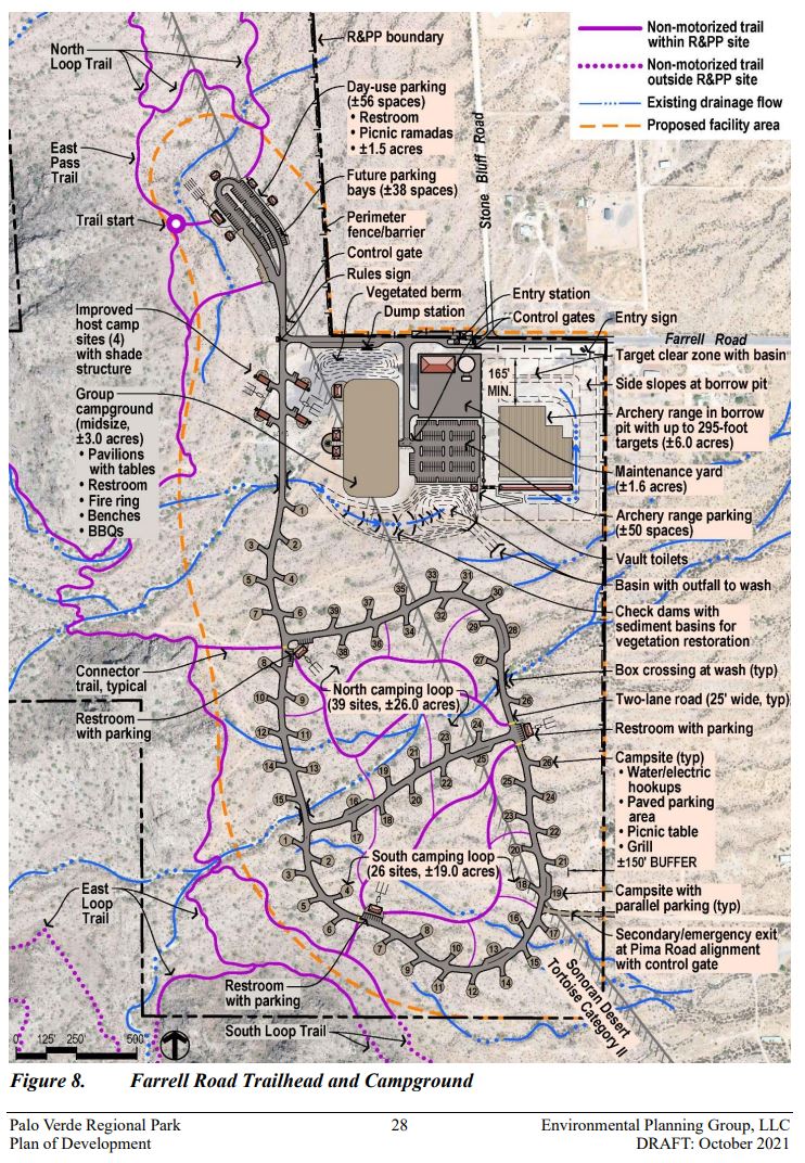
The county is introducing a non-motorized trail system, a day-use OHV staging area, an archery range, approximately 35 campsites with utility hookups, an RV dump, and several other improvements. There will be non-motorized trailhead parking areas and equestrian staging areas. These areas include bathrooms and shade canopies, signage, monuments, trash receptacles, maintenance facilities, and a host camping area.
Pinal County will improve the park with paved roads to access the park. Culverts will be installed at dry wash crossings to make internal roads accessible to park visitors. The county will install pipe fencing with an entry station and control gates around the perimeter.
The Palo Verde Regional park will take up approximately 493 acres of public land and cost around 31.5 million dollars to construct. It will be managed by the Pinal County Open Space & Trails Department, and entrance fees will be determined at a later date.
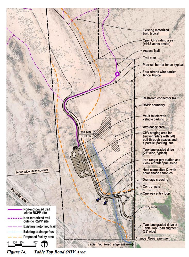
Not bad for motorized users
The estimated 3.7 million dollar OHV area will provide motorized users a place to offload their toys to enjoy the motorized trails around the area. It will include a 16.5-acre open OHV riding area that will allow cross-country travel and facilitate access to federal public lands.
The day-use OHV Area will include 20 pull-through parking lanes and a single parallel parking lane. There will be vault toilets and a host campground installed onsite with maintenance facilities and trash receptacles. The county will install steel pipe and wire fencing around the perimeter and throughout the park to control traffic. An Iron Ranger self-pay station will induce an honor system to collect payments from park visitors.
The OHV Area will also provide access to the proposed non-motorized Accent Trail that leads to the Desert Loop Trail in the Palo Verde Mountains and will provide access to the network of proposed hiking trails.
The Bureau of Land Management is asking for public comments.
Public comments are currently open for five different documents, and we are asking for your help in shaping the proposed plan. Please review the documents and provide your input to the Bureau of Land Management. This is your opportunity to help shape the language, procedures, and operation of this Pinal County Park.
Our Concern
Existing Roads
In general, we support these proposals because they assert local control over public lands, as long as the proposal doesn't affect our access. However, the future existence of several roads and other recreation areas concerns us. These roads would interfere with the proposed non-motorized trail system and would likely be closed along with popular target shooting areas sometime in the future.
One road provides access to a wonderful lookout near the top of the Palo Verde Mountains and would provide motorized users a route from the OHV area to the proposed archery range and non-motorized trailheads. The other road travels along the base of the Palo Verde Mountain range from north to south on the western side. This road circles the range in the valley below and is a significant part of the motorized trail system in the area.
We intend to assure the county will guarantee access to the surrounding areas by including specific languages in the proposed plan to recognize nearby roads as valid. We would like to see the BLM issue a Recordable Disclaimer of Interest in Land to the area's existing motorized and non-motorized roads and trails. Additionally, we would like to see the OHV staging area allow overnight camping and the park allow E-Bikes on some single-track trails.
Target shooting, dispersed camping, and "dispersed recreation" areas.
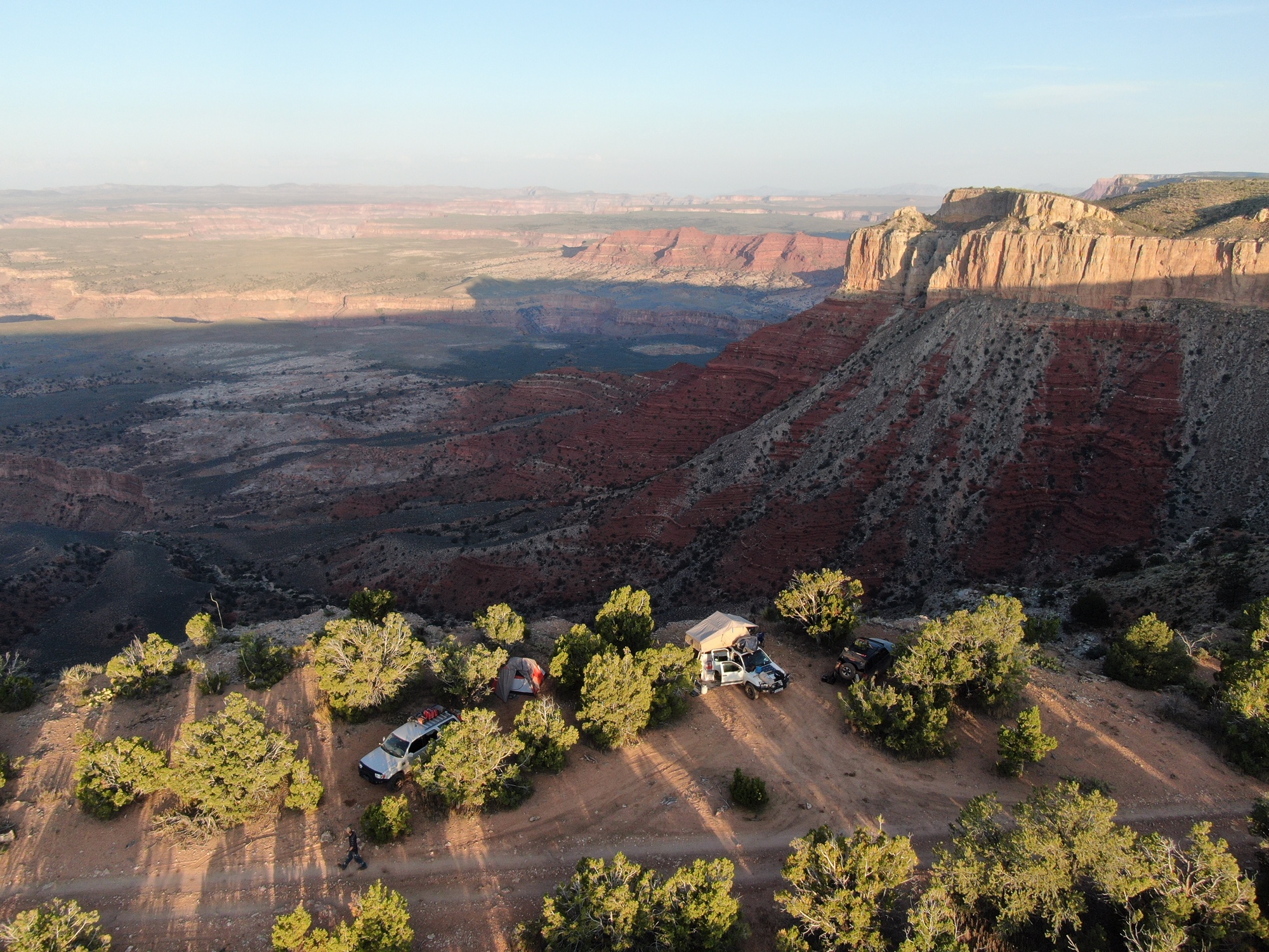
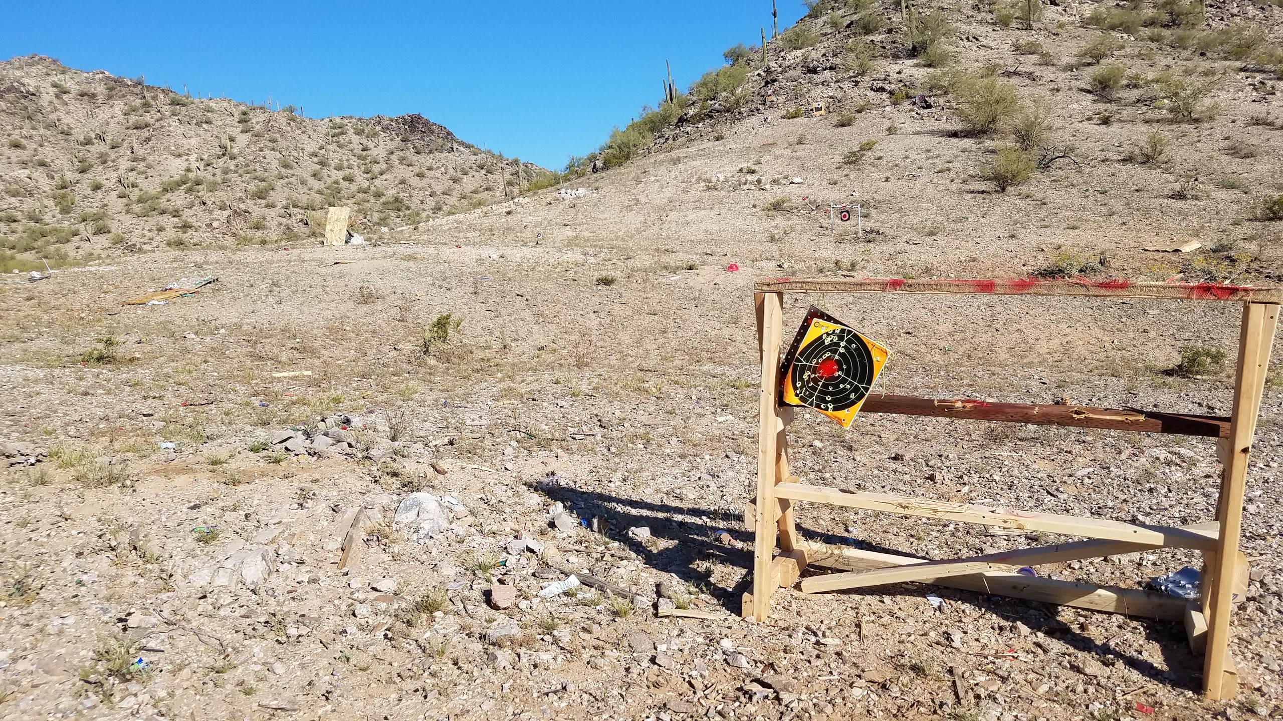
The Palo Verde Mountains are surrounded by existing dispersed camping and target shooting areas that this proposal could threaten in the future as conflicts may arise among users, and management may favor restricting use to the park.
We believe the Bureau of Land Management should clarify that dispersed camping, target shooting, and other forms of dispersed recreation can continue as normal in their current locations outside of the county park. Likewise, the county should consider including an outdoor shooting range or making improvements to existing target shooting areas to avoid future closures. These things would significantly improve the experience of users who take advantage of the park's facilities and protect future access to public lands.
Documents open for comment
We encourage you to review the documents below and submit a comment on each one. Please tell the Bureau of Land Management how to improve and perfect this proposal.
- Be sure to mention specific sections of the document and describe how the plan can be improved.
- Give solutions to achieve the goal of creating a county park.
- Tell how often you visit the area and how this proposal will improve or harm your recreation experience in the Palo Verde Mountains.
Substantive comments would:
- Question, with reasonable basis, the accuracy of the information in the Environmental Assessment;
- Question, with reasonable basis, the adequacy of, methodology for, or assumptions used for the environmental analysis;
- Present new information relevant to the analysis;
- Present reasonable alternatives other than those analyzed in the Environmental Assessment; and/or
- Cause changes or revisions in one or more of the alternatives.”
You can use the links below or visit the project website to submit your comments.
You must comment on each document separately.
The Draft Environmental Assessment and the Plan of Development have the most meaningful information.