

Tonto National Forest transforms how motorized users access the Forest
The Tonto National Forest has released the Revised Final Environmental Impact Statement for the Tonto Travel Management Plan. This revision is based on previous comments collected from the public. After fifteen years of planning, The Final Record of Decision will come sometime within the next few weeks and finalize the Tonto National Forest Travel Management Plan decision.
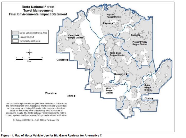
The Tonto National Forest is trying for Alternative C, transforming how motorized users access the Tonto National Forest. Among several other determinations, it will declare certain roads and trails for specific classes of motor vehicles and determine what roads will be closed.
Below we will give a fair breakdown of the travel management plan and the changes we are facing. We have linked to several documents. Ultimately, you should visit the Forest Service project website to review the complete set of documents. There is more to it than what can reasonably be put in the article, and the documents explain in detail what is happening.
PLEASE NOTE: If you previously submitted timely comments on the Tonto travel management plan, you can object to the Final Environmental Impact Statement.
Forest officials recommend Alternative C
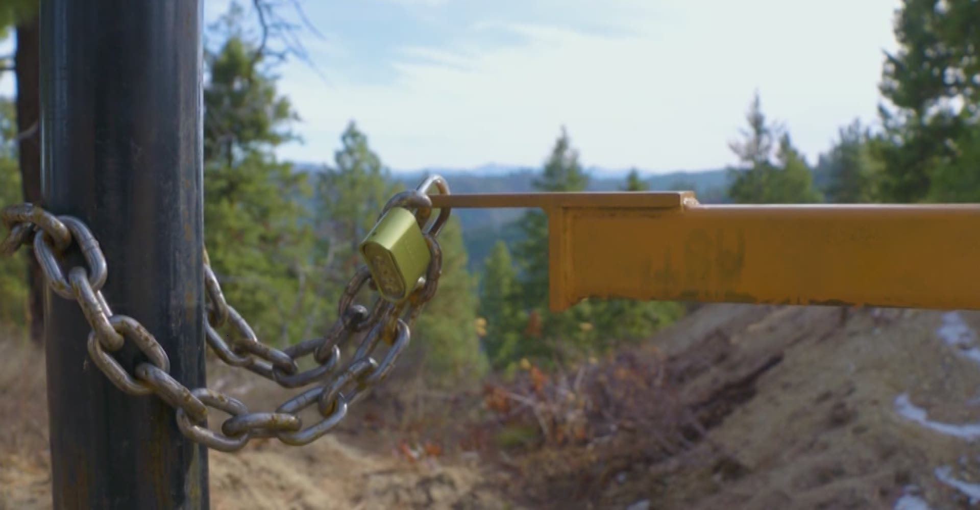
Closed Roads
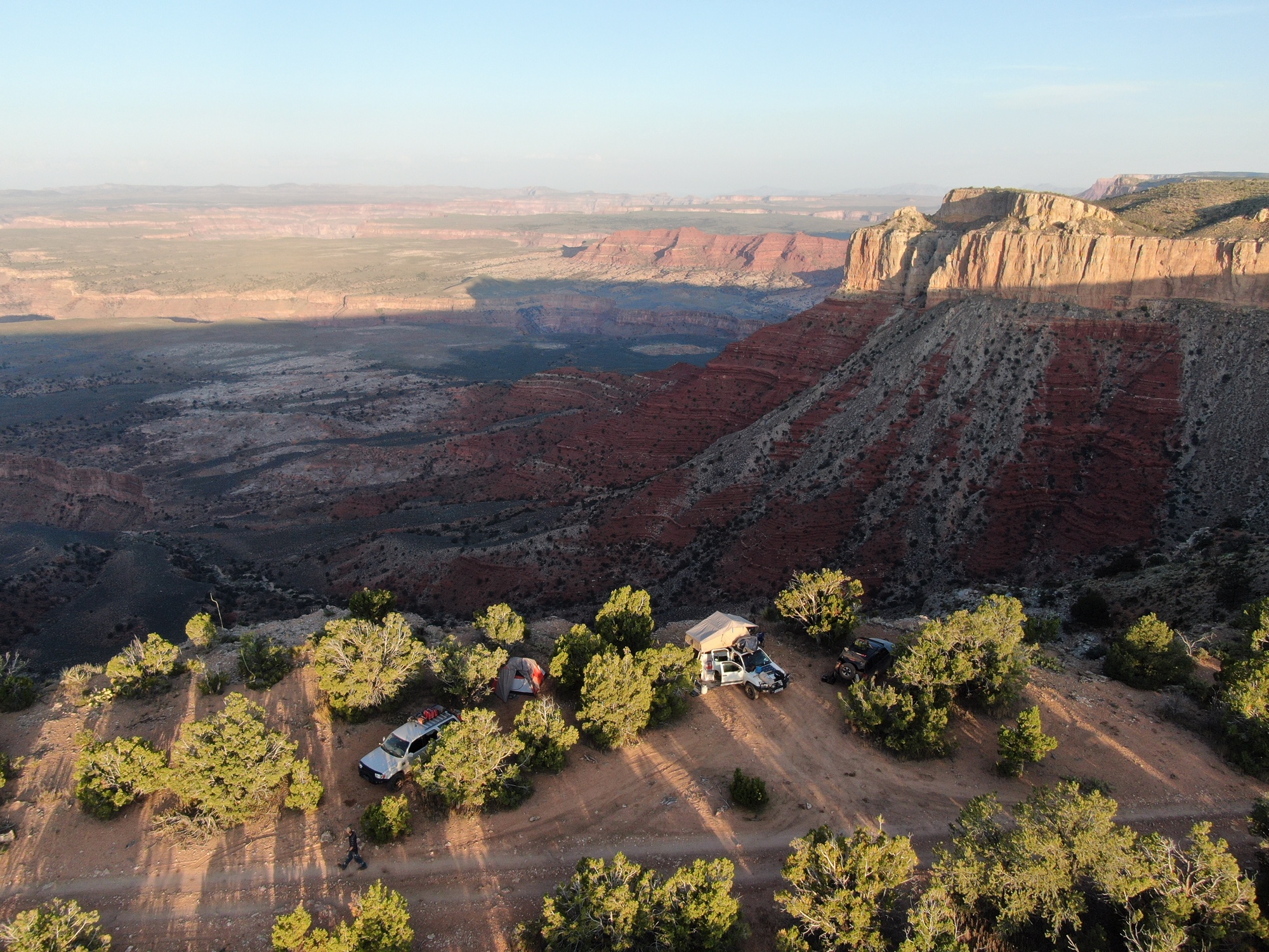
There are a total of 1,853 miles of roads proposed for decommissioning or downgraded to administrative use. Some of these roads are redundant or dead-end at private property. Others are existing roads that lead to dispersed campsites, mountain tops, and other historical places like cabins. Many of these roads are used by miners, ranchers, and recreationists to access water holes, mountain springs, and river beds.
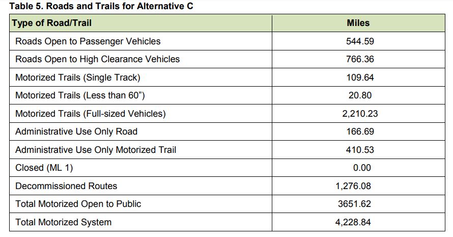
A total of 3,651 miles of trails will remain open to the public, but a few excellent 4×4 trails are now closing. This includes Red Creek Trail, Aztec Peak Trail, Cherry Creek Trail, and several trails around the Star Valley area. This decision also consists of 1,276 miles of roads completely decommissioned and 577 miles of roads downgraded to “administrative use.” 353 miles of roads will be added to the system. That includes 192 miles of two-track trails and 108 miles of single-track trails.
The Forest Service used several factors to determine what roads would be decommissioned. Routes that exceed a 10% grade, travel to mountain tops or ridgelines, across unstable soil, lead to places of cultural significance, have no destination value, travel through a wetland, or endangered species habitat are being considered for closure.
The Forest Service considered other criteria during the planning process. Roads that are located in roadless areas, roads where soil erosion is evident, roads that cause user conflict, the likelihood of driving into a wilderness area, and the proximity to wilderness areas all prescribe whether a road will remain open or not. All of these aspects are analyzed in detailed reports in the Forest Plan and the Travel Management Plan.
The Travel Management Plan incorporates other management decisions, like the Tonto Resource Management Plan, Fossile Creek Management Plan, The Tonto Wilderness Evaluation, and the Four Forest Restoration Initiative. It is somewhat of a grand finale where all management decisions come together to officially obliterate roads and remove them from future maps.
We are sad to learn that Forest Road 203 is closing.
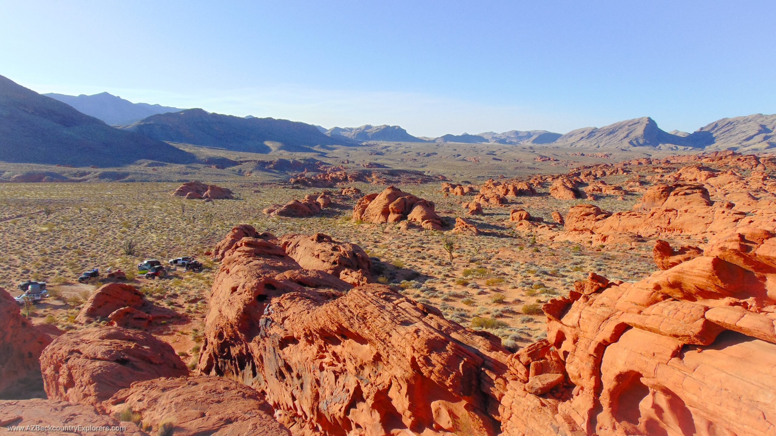
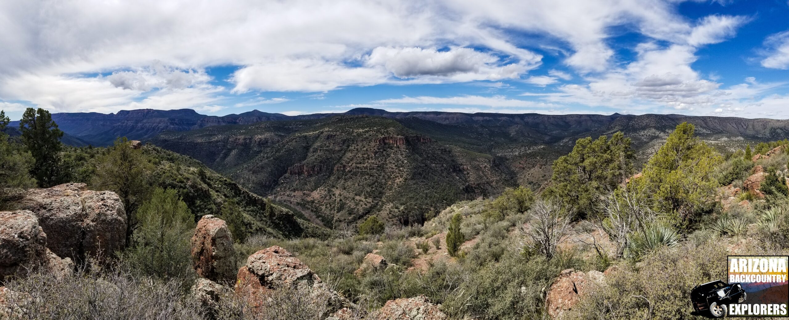
Cherry Creek Road is one of Arizona’s most iconic 4×4 trails. The road takes you through some of the most beautiful scenery in the Tonto National Forest. It’s visible on maps as early as 1909 and initially provided access to the Pendleton & Barkley Ranch. The road follows the border of the Sierra Ancha Wilderness, starting at State Route 288 and ending in Young, Arizona.
After several efforts to keep the trail open, the Tonto National Forest has refused to re-survey the Sierra Ancha Wilderness boundary. The Arizona Game and Fish, Gila County Board of Supervisors, and others submitted detailed comments concerning the wilderness boundary and the discrepancies with previous surveys.
In an objection, the Arizona Game and Fish writes,
“Regrettably, critical issues raised by the department about Cherry Creek road have not been adequately addressed. The department believes that the forest failed to provide an analysis or reasonable solution regarding Forest Service Road 203 Cherry Creek Road identified by the department as a critical route for public access.”
The Gila County Board of Supervisors also submitted comments objecting to the Forest Service’s decision to limit fuelwood gathering to 300 feet from the road and close access to the HAM repeater on top of Aztec Peak. They also praised the Tonto National Forest for committing to re-opening Cherry Creek Rd upon an act of Congress to re-align the Sierra Ancha wilderness.
Discrepancies in GIS data?
Documents in the Travel Management Plan have revealed, what I believe to be, the reason for the misaligned border of the Sierra Ancha Wilderness. On page 150 of the Final Environmental Impact Statement, the Forest Service explains how they intend to meet the Visual Quality Objectives. In that segment, they describe the discrepancies in Visual Quality Objective GIS data.
Up until 2006, maps of the Tonto National Forest were recorded on translucent mylar film, and according to the Forest Service, when integrated into modern GIS systems, they created significant discrepancies.
The Forest Service writes,
“Since the Visual Quality Objective maps were integrated into the GIS system in 2006, there have been numerous changes in the versions of GIS software the forest uses, causing differences in forest boundaries, wilderness boundaries, etc., which has contributed to discrepancies.”
Did the same “discrepancies” occur with the Sierra Ancha Wilderness boundary when the Forest Service integrated these mylar maps with modern GIS software? Human error could have resulted in the misaligned Sierra Ancha Wilderness border, whether intentional or by accident.
If you notice, there is a disclaimer on each screenshot below notating that the “Forest Service reserves the right to change GIS products at any time.”
Permit Zones and OHV Areas
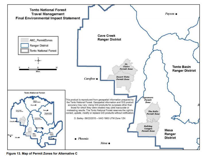
The Preferred Alternative C creates three additional permit zones, including Desert Vista, St. Clair, The Rolls, and the existing Bulldog Canyon, for a total of 116,798 acres. The Forest Service will now gate these areas and require motorized users to obtain a free permit with a gate code. The permit is essentially a contract between the user and the Forest Service where the user agrees to follow specific rules while visiting the said area. Permit numbers could be limited, and it will serve as a deterrent to effectively reduce the number of visitors. The permit will also allow authorities to give motorized users the Ban Hammer and deny future permits.
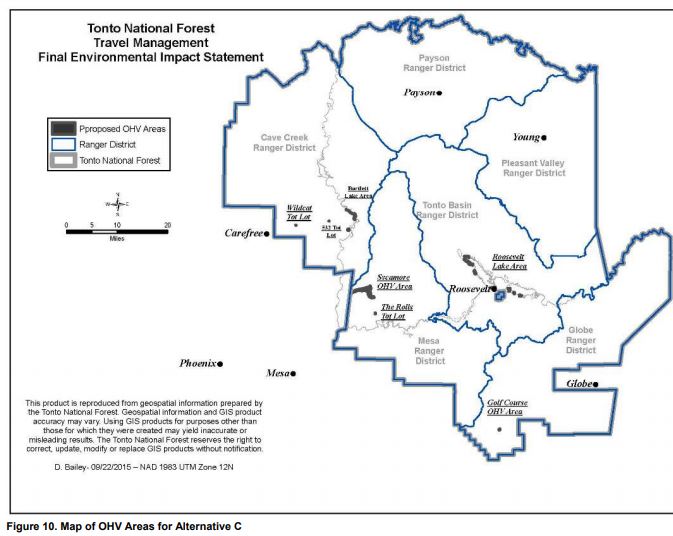
In addition, there will be several new OHV areas created at Bartlett Lake, Roosevelt Lake, Golf Course, and Sycamore, including four tot lots where kids can safely ride. Cross-country travel will be limited to these areas and provide unrestricted motorized use on 2,088 acres of public land.
Dispersed camping
Dispersed camping is taking a hard hit.
The common 30-foot rule for dispersed camping on the side of the road now only applies to the Payson and Pleasant Valley ranger districts.
Dispersed camping in the Mesa, Cave Creek, Tonto Basin, and Globe ranger districts will be limited to designated campsites only. A total of 94 miles of side roads will provide access to 2,864 dispersed campsites. The Forest Service will not implement this action until sometime in the future.
According to the Forest Service,
“They will need to be surveyed for cultural resources and to make sure they are not within congressionally designated areas, inventoried roadless areas, or special management areas that restrict the use of vehicles to system roads.”
The Arizona Game and Fish inventoried dispersed campsites in the Tonto National Forest.
The Arizona Game and Fish inventoried dispersed campsites in the Tonto National Forest and determined there are a total of 2,864 campsites that meet the criteria of the Forest Service methodology. Arizona Game and Fish then eliminated campsites from the analysis that are within 100 feet of wilderness areas and are along roads proposed for closure in the Travel Management Plan.
Dispersed campsites that enter Inventoried Roadless Areas were also eliminated from the analysis. According to Arizona Game and Fish, these campsites contradict the Inventoried Roadless Area Conservation Rule set by the USDA Forest Service. Their offered alternative is “to pack in their camp with non-motorized means if they desire to use those particular sites.”
This includes 2 campsites outside of the Hells Gate Wilderness along forest road 1673. 24 campsites near the Sierra Ancha Wilderness along forest roads 203, 487, and 487A. (Aztec Peak and Cherry Creek Road). 10 campsites near the Superstition Wilderness and 13 others in roadless areas.
The report titled “Arizona Game and Fish Department Report for Inventory of Motorized Dispersed Campsites in the Tonto National Forest” mentions that most motorized dispersed campsites are within 100 to 300 feet from the main road, which is consistent with previous dispersed camping rules. However, Arizona Game and Fish and the USDA Forest Service deem these user-created roads as “unauthorized” when they are authorized under previous regulations.
Cross-country travel, big game retrieval, and fuelwood cutting
Motorized cross-country travel will no longer be allowed forest-wide. Instead, users must stick to designated OHV areas. As mentioned above, several new OHV areas will be created where users are not limited to designated roads.
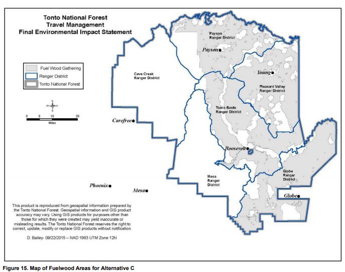
Firewood permit holders are allowed to drive 300 feet from the road to cut firewood in designated areas only, as shown on the map below. According to Gila County, this decision is burdensome on rural Gila County residents who use firewood in the winter months.
Alternative C will also allow hunters to travel up to one mile off the trail to retrieve big game species. Motorized big game retrieval will only be permitted in designated areas, as shown on the map below. Hunters will be required to pick a path that is unrecognizable to other users to avoid continued use.
Documents
Object to this decision by sending your comments to:
Calvin Joyner
Tonto National Forest All Units
333 Broadway Ave. SE, Albuquerque, NM, 87102
objections-southwestern-regional-office@usda.gov
Or use the form below to write an objection
Object to the Tonto TMP
Thoughts
It’s a shame that we are losing so many trails and campsites.
We understand that most people don’t want to equate political jargon with their weekend getaway. Our adventures are supposed to be our escape from this crazy world we live in. Unfortunately, some groups want to close access to all users. If we don’t stand up for the original idea of multiple use, we will lose motorized access and, therefore, lose our ability to reasonably access our public lands.
Little by little, our access is being chipped away. We must be aware of radical environmental groups, politicians, and the poisonous ideology they push on motorized users. We are not bad people. We do not destroy or harm anything by traveling down a forest road.
Pro-motorized groups, clubs, and organizations have fought for decades to keep motorized access open by maintaining trails, getting involved in policy, and following basic trail etiquette guidelines. As the new generation of motorized users inherits the wide-open access that previous groups have preserved, we must ensure that we can follow in their footsteps and keep these roads open. It is the responsibility of every motorized user.
The statement that we need to protect wildlife, plants, and historical artifacts from some invisible boogie man is absurd. These roads have existed long before us, and the reality is, beauty exists in the Tonto National Forest. It always has and always will. Despite what you’re told, ranchers, miners, and motorized users care deeply for the land. No motorized user wants to create new trails; no miner wants to level mountains, and no rancher wants to overgraze. If we didn’t care, it would all be destroyed by now.
For anyone who disagrees, I have one question for you. How does such beauty and cultural richness exist with such a diabolical threat unchecked for so long?