• Facebook
  • Twitter
  • Link
  • Home
  • Membership
    • Member Dashboard
    • Expeditionist Only
    • Change Password
    • Forgot Password?
    • Support Us
    • Pick A Membership
  • Store
    • AZBackroads Store
    • Cart
    • Subscriptions
    • Hats
    • Hoodie
    • Wall Art
    • Downloads
  • About Us
    • About Us
    • Connect With Us
    • Report A Trash Dump
    • AZBCE Ambassadors
    • Our Allies
  • The Backcountry
    • Arizona 4×4 Routes
    • Wildfires & Restrictions
    • Forest Alerts
    • The Guide to camping
    • Trail Etiquette
    • Arizona state trust land permit

ACTION ALERT | Buckeye Hills Travel Mgmt | 354 mi of roads CLOSED Rainbow Valley

BLM, Call To Action, Land Use, Travel Management Plan

Written By

Kevin Allard

September 15, 2022

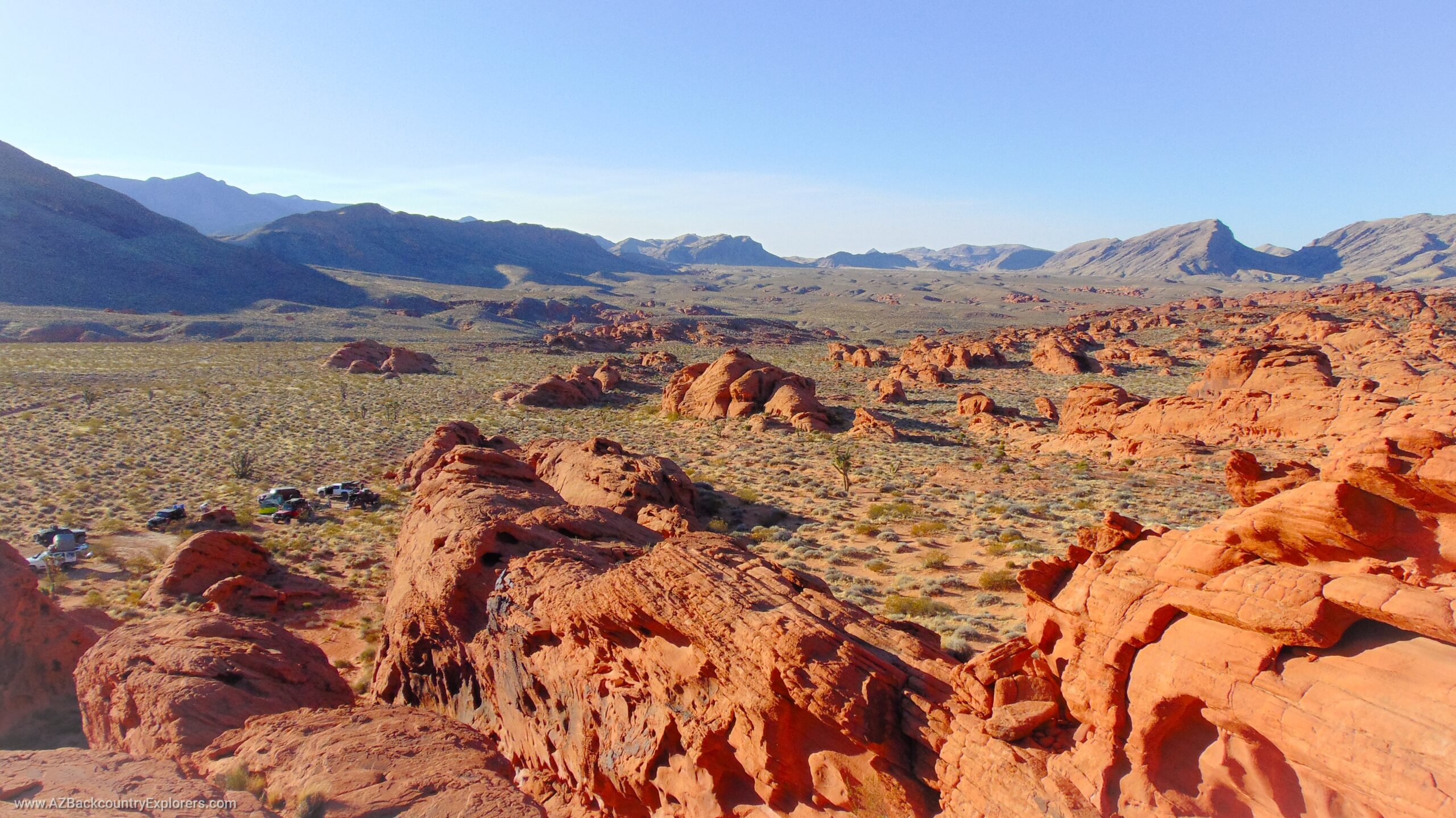
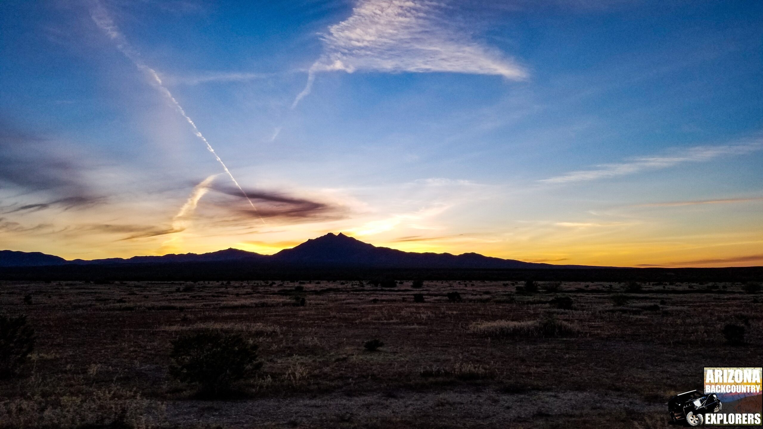
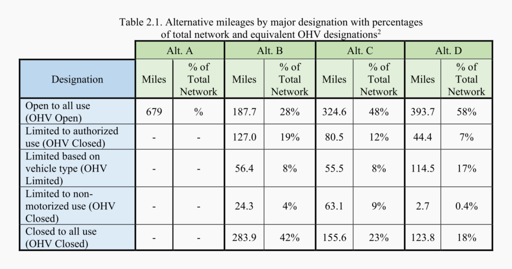
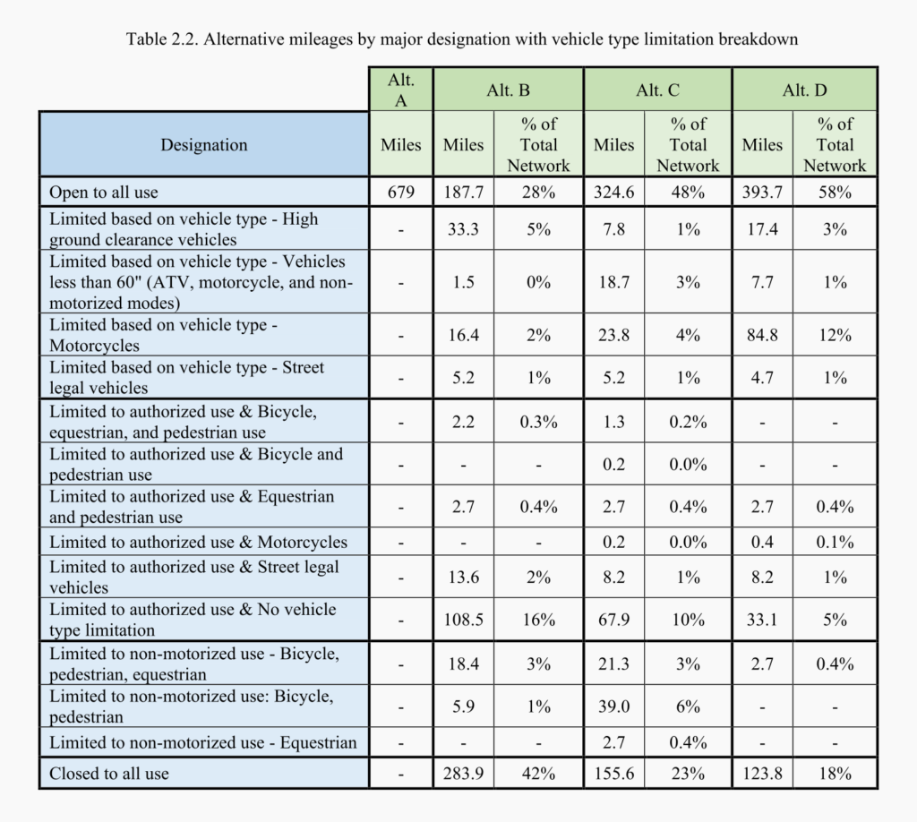
Buckeye, Arizona – On August 31, 2022, The Bureau of Land Management concluded a final decision on a Travel Management Plan for the Buckeye Hills and Rainbow Valley area just west of the Sierra Estrella Mountains near Buckeye Arizona. The final decision consists of 679 miles of roads in the 572,159 acre Buckeye Hills East and Buckeye Hills West Travel Management Areas where only 324 miles will remain open to all users. A total of 354 miles of existing roads will be permanently closed or restricted to the public under the preferred Alternative C.

This plan has been in development since 2001 and is one of several travel management plans that was withdrawn in 2018 due to the collective effort of Arizona Backcountry Explorers and numerous clubs, organizations, and political representatives across the state.

The Bureau’s decisions are coming fast

As we have shown, in the past couple of months the Bureau is releasing its final decisions out of nowhere. Bouse, Cactus Plain, Black Canyon Corridor, Littlefield, Arizona Strip, and now Buckeye Hills final decisions have all been released this year and we have issued action alerts for all of them. These plans have not been listed in the Bureau’s official NEPA register for nearly 4 years and there has been no attempt to contact the local political subdivision or those who use these roads. All of the original documents from the entire NEPA process have disappeared. GIS data is being hidden deep in the agency’s server. The Bureau is no longer making interactive maps and we are being left with PDF maps to see what’s closing.

Luckily, we have access to the agency’s data which they have desperately attempted to hide from the public. We know, through this hidden but publically accessible data, that the Fortuna Hills and Kingman Travel Management Plans will be released at any time. These plans include nearly 4,000 miles of closures in about 10 different travel management areas in the far western end of Arizona. Due to this recent trend, the Bureau will likely release these decisions without warning too.

We feel this is problematic as many of these plans never completed the public outreach process required by the National Environmental Policy Act. Likewise, the bureaus failed attempt to notify stakeholders imposes an unfair disadvantage on public land users. In our opinion, all of these plans should have, at a minimum, been brought back to the drawing board and reopened for public comment or permanently withdrawn. The final decision is no different than the previous proposals that were withdrawn in 2018 and that caused major controversy among the local motorized users and political subdivisions that have broad authority over these roads.

Historical roads exist in the project area that is now being closed. Some of these roads have existed for 100 years or more and are property rights granted to the states under Section 8 of the Mining Act of 1866. Federal and State laws give the local political subdivision broad authority over these roads and detail a strict process to abandon, vacate, and close a public right of way.

The appeal process for the Buckeye Hills decision ends on September 30, 2022.

Once the decisions are released, the National Environmental Policy Act gives individuals and local clubs who have submitted a substantial comment on the plan, a 30-day window to appeal the Bureau’s decision. This is where our action alerts come into play. We must make sure the local political subdivision appeals to the Bureau’s final decision.

Use the interactive map below to view the final decision

Use the form below to send an email to the local political representatives in County and State government. Edit the message or use our pre-written message.

Send your comments on Buckeye Hills TMP

Read or Edit the Petition

You can add formatting using markdown syntax – read more


This message was sent from an Arizona Backcountry Explorers Call To Action. AZBackroads.com
 

Read the Documents and Final Decision on the Project Website

Visit the Project Website
Kevin Allard [#facebook#]
Author: Kevin Allard

Kevin is an American outdoorsman born and raised in rural Arizona who grew up exploring the Arizona backcountry with his father. Today, he and his son travel to the most remote regions of Arizona, scavenging for the remains of early western pioneers. As a lifelong outdoorsman, Kevin has learned to stick close to his roots while engaging in important advocacy work regarding motorized access to public lands. You can find his work in many local and nationwide publications, including The Western Journal, 4Low Magazine, and his website AZBackroads.com.

Share this:

  • Twitter
  • Facebook

Tags:

Avondale, Buckeye, Buckeye Hills, Dispersed Camping, Gila River, Prospecting, Rainbow Valley, Road Closure, RS 2477, Sierra Estrella Mountains, Target Shooting, Travel Management, Wilderness

We Need Your Help To Keep Our Backroads Open!

Please become a member today!

Learn More
  • SPECIAL REPORT | Desalination: A monopoly on western water

    SPECIAL REPORT | Desalination: A monopoly on western water

  • ACTION ALERT | Table Mesa Recreation Area Management Plan Revision

    ACTION ALERT | Table Mesa Recreation Area Management Plan Revision

  • ACTION ALERT | Middle Gila Travel Mgmt Plan Starts | Access to 350k acres threatened

    ACTION ALERT | Middle Gila Travel Mgmt Plan Starts | Access to 350k acres threatened

  • ACTION ALERT | permit zones Tonto NF | $10 fee Bulldog Rolls Sycamore St Clair Desert Vista

    ACTION ALERT | permit zones Tonto NF | $10 fee Bulldog Rolls Sycamore St Clair Desert Vista

  • Black Canyon TMP Final Decision | Approx 260 MI of existing roads CLOSED

    Black Canyon TMP Final Decision | Approx 260 MI of existing roads CLOSED

  • ACTION ALERT | Buckeye Hills Travel Mgmt | 354 mi of roads CLOSED Rainbow Valley

    ACTION ALERT | Buckeye Hills Travel Mgmt | 354 mi of roads CLOSED Rainbow Valley

  • ACTION ALERT | Bouse & Cactus Plain Final Decision | 1,049 mi of roads CLOSED

    ACTION ALERT | Bouse & Cactus Plain Final Decision | 1,049 mi of roads CLOSED

  • ACTION ALERT | Proposal calls for diversion tunnels around Glen Canyon Dam

    ACTION ALERT | Proposal calls for diversion tunnels around Glen Canyon Dam

  • ACTION ALERT | 54% of Roads CLOSED Near Black Canyon | NEW PROPOSAL

    ACTION ALERT | 54% of Roads CLOSED Near Black Canyon | NEW PROPOSAL

  • RED ALERT | Additional 31,000 Acres Added To Sedona Camping Closure (81k Acres)

    RED ALERT | Additional 31,000 Acres Added To Sedona Camping Closure (81k Acres)

Please become an AZBackroads.com Member

As a member, you unlock access to:

  1. an incredible collection of GPS tracks.
  2. a collection of over 1,300 Points Of Interest.
  3. and commentary from the author, free merch, and a discount on all products in our store.

We Need Your Help

Learn More

Welcome

Log In
Sign Up

Accepting

  • Facebook
  • Twitter
  • Gab
  • About Us
  • Connect With Us
  • Report A Trash Dump
  • AZBCE Ambassadors
  • Our Allies
  • Take Action Now
  • Privacy & Return Policy

The Backcountry

  • Help Save Apache Trail
  • Arizona 4×4 Routes
  • Wildfires & Restrictions
  • Mapping Adventure
  • Forest Alerts
  • THE Guide to Camping
  • Trail Etiquette
  • AZ State Trust Land Permit

Membership

  • Member Dashboard
  • Members Only
  • View Profile
  • Edit Profile
  • Change Password
  • Log out
  • Support Us

Store

  • AZBackroads Store
  • Membership
  • Hat
  • Shirt
  • Hoodie
  • Wall Art
  • Download
  • Cart

This website is built and maintained by Kevin Allard. All content on this website is protected by Copyright and shall not be redistributed without written permission by the author. The Arizona Backcountry Explorers and AZBackroads.com name and logos are registered trademarks of Kevin Allard. Names and logos of our partners, affiliates, and syndicates are registered trademarks of their respective owners.